There is a storm system that will likely effect the region. Monday night through Tuesday
First flakes will likely fall in southern New England
Timing
The sooner the Precipitation starts the more snow we will see and the less sleet/freezing rain.
Is there a clean transition from snow to rain or is there a long period of sleet/freezing rain
What low pressure is stronger
There are two scenarios that I see could play out.
One involves everyone starting out as snow around 3am Tuesday morning. turning from snow to rain from south to north. Everyone turns to rain by 1pm This would mean more snow.
Second possibility is that the precipitation starts between 2 to 4am as snow but quickly changes to rain east of i95 but changes to heavy sleet/freezing rain and rain west of I95 for most of the morning. This change over could make its way up to central New Hampshire. This scenario will lead to less snowfall than possibility one, but this involves more Ice and less rain
For now I am leaning to a mix of the two possibilities.
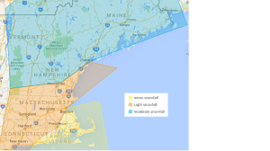
Here is the first snow map of the season. It is not much but its at least something.
Minor snowfall across southeast Massachusetts
Light snowfall in the regions shaded in red. The higher amounts of course the further north you go.
Blue is where moderate snowfall could fall.
Please go to to the Merrimack Valley Precaution/watch.scale page on the top of this page to better understand the ranges of snowfall.
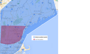
Also the likely hood of winter precipitation effecting travel has increased for the period from midnight Tuesday morning to Tuesday afternoon.
A winter weather watch has been issued by Merrimack valley weather.
There is also an Ice precaution for portions of the region. The Merrimack valley is under both the winter weather watch and Ice precaution.
Remember these are issued by myself not the national weather service. These are just measurements of how confident I am in the forecast of winter weather effecting the region. and travel. More maps to come out as more information comes out from the weather models tonight.


