
Everyone by now knows about the storm that will likely effect most of the region (realize I said likely) It depends on your location. The further south you are the better chance of winter storm criteria being met.
An area of low pressure will be traveling up the east coast, but its actually not just one area of low pressure, the first low has moved off shore, there is an other low that will be traveling up the east coast to give areas like NJ, NY and Southern CT a decent snow storm. The snow will move its way into southern New England but will be fighting the dry air as it moves northward. Snow will likely start in the morning in CT and we will probably not see much in the way of snow until 5ish or later. Areas along the Mass/NH boarder should not expect a big storm despite those stupid phone apps saying other wise. Remember those phone apps are based on a singular weather model in most cases.
With this storm, the weather models are still all over the place, but looking at current conditions, wind patterns, radar and satellite imagery we can see that the storm is struggling against the dry air to the north. The northern areas of the precipitation shield is actually not hitting the ground as the dry air is eating the snow.. On radar it would look like it should start snowing this afternoon but do to the dry air and high sun angle we will struggle to see any accumulating snow in areas north of the pike. With areas south of the pike to start seeing accumulation at some point this morning and afternoon. Do to the dry air, timing and my thoughts on how far the precipitation will make it. my snow numbers are much lower than many. I have to admit, this could be dead wrong but its my best idea. You might see this change late this afternoon, as this will be what meteorologist like to call a now-forecasting event.
The areas that are seeing snow right now will likely be the areas that see the most snow.
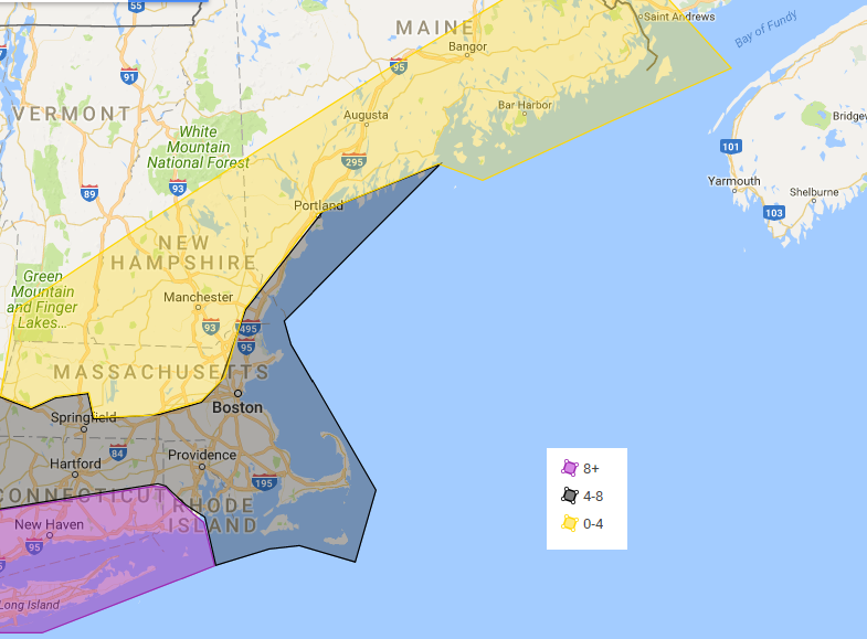
In the purple shaded areas 8 or more inches is likely and there could be pockets of up to 18 inches depending on snow banding in that region. a general 4 to 8 inches in the black shaded areas, expect the lower end of the amounts especially the further north you are and if your on the cape and islands. If there is mixing on the outer cape less than 4 inches can be expected. If it doesn’t mix it will likely be in the range. There could be some locally higher amounts in interior SE mass. Due to the dry air there will be a sharp cut off in snowfall. Areas in the yellow has a range of 0-4 because some where in this area will be the cut off. Again I could be dead wrong, there could be much more snow and this forecast busts but I truly believe that the dry air will play a huge part in limiting snowfall amounts especially across Northern Massachusetts. Snow accumulation will be based on the heavier snow bands and tonight.
The coast will likely see light to moderate coastal flooding. Winds will be strongest along the coast and south of the pike with wind gusts in the 40s and 50s.
Forecast for the Merrimack Valley.
Today. Cloudy, with a chance of snow southern areas late. Chance of flurries north Highs in the lower 30s.
Tonight. snow south, snow showers likely north. Snow could be heavy at times south. lows in the upper 20s. Breezy winds N at 10 to 20MPH with gusts in the 40s
Thursday. Snow likely in the morning then cloudy in the afternoon highs in the 30s.
Thursday night. Mostly cloudy, lows in the upper 10s to mid 20s.
Friday through Saturday mostly to partly cloudy highs in the 30s, lows in low to mid 20s
Sunday and Monday. Partly to mostly cloudy, highs in the mid 30s to low 40s. lows in the 20s.
