
You probably have seen “winter forecasts” as early as August maybe even before. Lets just say many aspects of the winter forecast would have changed since then. Just saying. 😉There are three sections in this winter forecast. If you want to just see the Northeast forecast got to the bottom. First section shows the different signals for the up coming winter that forecasters use to predict the winter. Followed by maps of precipitation/temperature and snowfall/ice. With the the last part being the regional forecasts. ( please look at the map of the usa using the icon above to see where you are in terms of this prediction)

1= Below normal SSTs = negative ENSO
3. below average SSTS variable pacific jet?
4 Above average SSTs
When you read the tittle you might say oh it might not be a bad winter, that is just referring to all the teleconnections that weathermen look at for their predictions as many of them are giving mix signs and or canceling each other out.
SSTs – sea surface temperature: Below normal in area 1 where we measure the ENSO. There are currently below normal temperatures off the pacific NW but this could change with a build up of warm water moving north from California waters. Very warm warm off the NE coast.
ENSO is in a negative phase ( La Nina) ( look above at SSTs map) usually leads to dry and warm conditions for the southern tier of the country. Southern new england can see variable conditions with wetter conditions Pacific Northwest to the ohio Valley to Great Lake
PDO is negative. This generally leads to drier and warmer conditions in the southern tier of the country.
AO Negative phase ( allows cool air to move down from the Polar regions) Bulge in the jet stream
PNA Positive, history shows active winter for the east
NAO: AO and NAO correlate usually which means NAO could be rather negative this year unlike the last few winters. This allows for blocking on the east coast. This will be variable.
QBO is likely going to be in the Eastern Phase (generally leads to cooler than average temperatures across the Great lakes and East
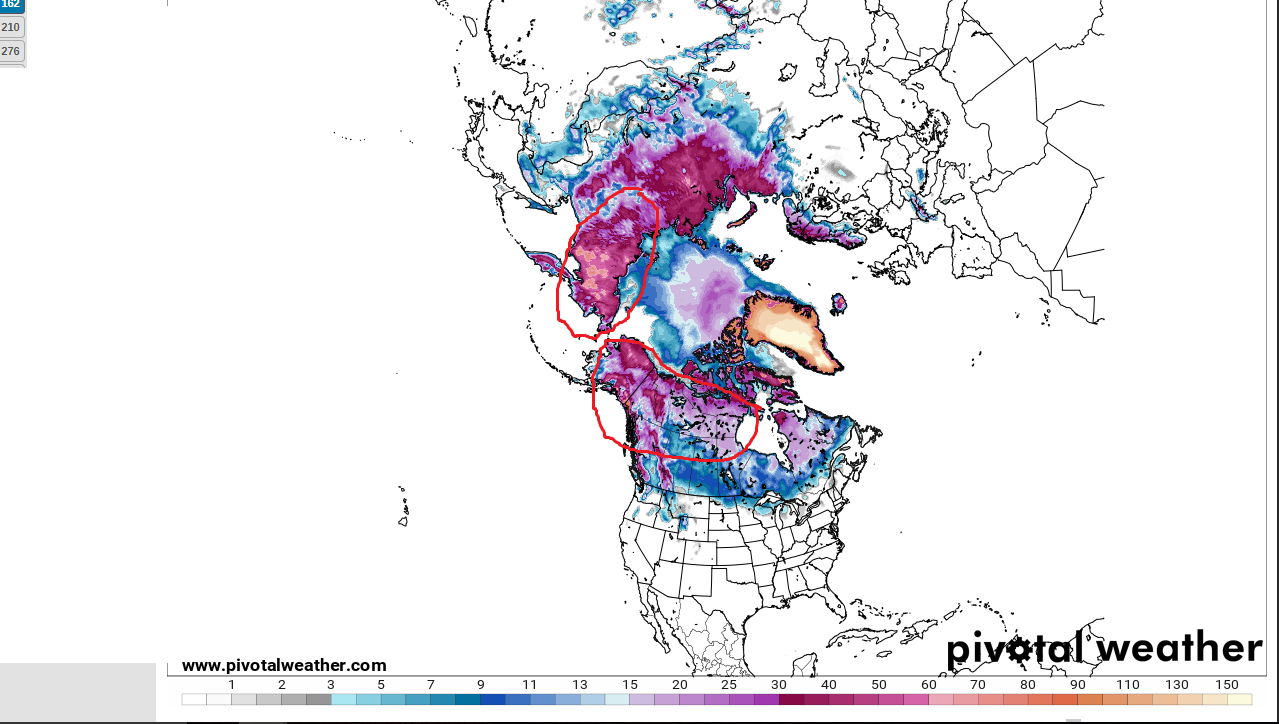
Snow depth of the Northern Hemisphere. Cirled areas are areas in which forecasters look for snow cover/speed of snow cover
Snow cover over Siberia and Canada are ok this year for build up of cold air masses. ( there is as reason why Northwest Canada is called America’s Ice Box)
Above average Ocean temperatures off the mid Atlantic and Northeast coasts up into Canadian maritimes. ( if the pattern is right, can lead to large Nor-Easters as cold air from Canada moves down and interacts with the warm ocean water). Though this warmer than average ocean temps can lead to more messy mix events along and east of I95. ( SSTs map)
With all of these in mind, different parameters are weighed more and less than others. The southwest, Southern Rockies, plains are areas of higher confidence with the northern tier of the country being less clear. There can be huge bust potential with any winter forecast for the northern half of the country, especially the pacific Northwest and Northeast this winter.
Visual Maps: storm tracks Precipitation, Temperatures, Snowfall.
( remember these are from the normal precipitation, temperature and snowfall for the areas. For example Below normal is compared to the normal of that region. An area thats normal of 40 inches having a snowfall amount of 25 is below for that region, while an area that average snowfall is around 12 inches lets say 25 would be considered above normal snowfall for that region, same with temperature and Precipitation.) I can not stress this enough. It also only takes a few storms to make a winter a “snowy one” Winter patterns can vary greatly from month to month, week to week and day to day. There will be times that it will be cold where above average temperatures are expected. Same with precipitation, snow and Ice even if its below normal you can have periods in which its not the case.
Storm Track

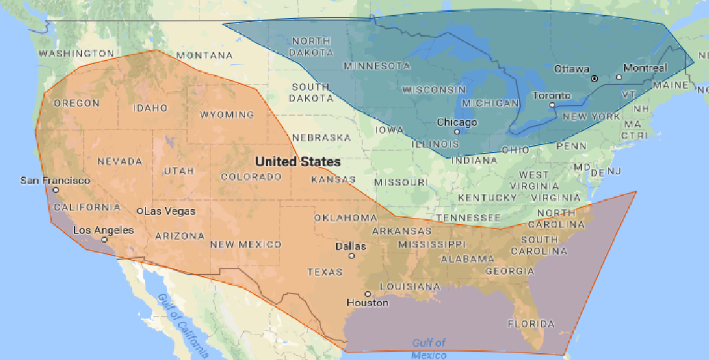
Variable pacific jet stream will be influenced by a ridge in the south, this ridge can shift west and east though out the winter, which is why you see a mix of possible storm tracks. The storm tracks will be rather variable this winter with different tracks favored at different times of the winter. There can be times this winter in which a trough in the east (lakes and Northeast) and ridge in the southeast happening at the same time acting like a funnel in the Ohio River Valley the placement of the troughs will determine storm track. Ridge in the southeast with no trough in the east, storms travel interior NE and great lakes which could involve icy situations. . There will be times as well in which quick moving clipper like systems come quickly down into the northeast (purple). As storms move west to east, they will be followed by cooler temperatures and windy leading to lake effect snow in the great lakes.
With that said here are the temperature/precipitation/snow/ice predictions from normal.
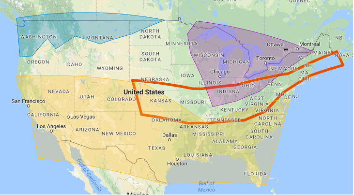
Red =color Above average temperatures
Blue =Normal to below normal temperatures
no color= equal chance of below and above/around normal
Temperatures: As it stands now the southern half of the country looks warm with above average temperatures ( red) Areas in blue will have the best chance of below normal temperatures. Areas that do not have a color have equal chances of being below or above normal temperatures. This includes the northeast. Further South your located the better chance of having above normal temperatures. If the pattern stays progressive with not as much blocking a more zonal flow will be anticipated with warmer than average temperatures for most of the USA.

Yellow= below normal
light green: normal to above normal
Dark Green. Above normal no color= equal chance of below/above normal/ around average
Precipitation. Best chance for above normal precipitation will be over the Ohio river valley, great lakes and interior Northeast. With normal to above normal across the northwest to New England. In the east a few storms can make or break the precipitation forecast.
snowfall: The pacific northwest looks to have average with localized areas of above normal snowfall by the end of winter. The snowiest areas will be the northern Ohio river valley, Great lakes and interior western Northeast. Blocking will play a major role in determining snowfall this winter particularly in the Northeast.
Orange= below average snowfall.
Blue = normal to above normal snowfall
purple= above average snowfall
no color = equal chances of above and below/ average snowfall.
Area inside red line, ICY
ICE: Areas in side the red lines have a good shot at seeing some nasty Ice storm this winter. The way the pattern is looking up to be, storms could form and move over the cold air as low level cold air can be rather stubborn. Especially storms in which travel over the Appalachian MTNS with retreating cold high pressure systems.
Regional Predictions:
Northwest. Variable Pacific Jet stream will send rainy conditions with Mountain snows. Overall Temperatures look be on either side of normal with Oregon favoring the warmer side. Precipitation looks to be normal to above normal across Washington with equal chances of below and above else where. This is the average, there will be variability throughout the winter in terms of both temperature and precipitation. Snowfall looks to vary depending on location be (look at map).
Pacific Southwest ( desert southwest included): Dry and Warm. Below average precipitation, above average temperatures. Below normal snowfall
Rockies: Generally above average temperatures but equal chances of below and above average northern Rockies. Northern Rockies normal to above normal precipitation. Equal chance of above and below normal precipitation central Rockies, with below normal precipitation southern Rockies. Snowfall around normal to above average for northern Rockies. With equal chances of both below and above normal snowfall central Rockies. Below normal snowfall southern Rockies.
Plains: Southern Plains, warm and dry with below normal snowfall.
Central plains around normal with equal chances of above or below normal temperatures. Precipitation looks to be around normal to above normal. Equal chances of above and below normal snowfall. Snowfall around normal. This area could be dealing with a few Ice storm situations.
Northern plains. Normal to below normal temperatures with around normal to above normal precipitation. Around average snowfall, Equal chances of below and above normal snowfall.
Southeast USA. Warm and dry but not as dry as the Pacific southwest. Above normal temperatures, below normal precipitation, below normal snowfall.
Mid-Atlantic. Normal to above normal temperatures. Normal to below normal precipitation south and east, normal to above normal northwest. Snowfall below. Interior locations could be dealing with ice storms especially Mountain areas.
Ohio Valley: Normal to above normal precipitation. with around normal to below normal temperatures. Snowfall normal to above normal. Ice events are likely this winter. Unlike previous winters thoughts are that this will be a more typical Ohio valley winter.
Great Lakes. Below normal temperatures, Above normal precipitation. Above normal snowfall. Lake Effect snow machine will be at full strength this winter. Storm tracks will be favorable for large snow followed by large lake effect snows.
Northeast. Temperatures, have equal chances of being below or above normal this winter. Precipitation look to be normal to above normal, especially the further west and north you are. The typical nor-Easter might be hard to find this winter, but when they do form, they could be very powerful storms as the cold air masses come down from Canada meet the warm moisture rich Atlantic air. Do to the abnormally warm ocean temps, they may also limit snowfall along the I95 corridor and eastward. Normal to below normal more favored south and east with normal to above normal favored west and north. In general though there is a rather equal chance of below and above normal snowfall. It looks like it could be a decent ski season this winter and early. There will be storms that travel west around the Lakes, being a warm situation and provide icy situations especially when a nice cold area of high pressure sits on top the region. Storms could travel over us as well providing snow/Ice to rain, There are also quick moving weak systems that can get stalled off our coasts do to blocking and explode do to the warm ocean temperatures. Due to the variable Pacific jet stream, there could be wide temperature swings throughout the winter but due to favorable conditions for blocking this winter, long periods of cold and warm times are likely. The wind will generally be howling from the northwest after storm systems. The strength of the northwest flow following storm systems can lead to lake effect snow showers to spread further east from the Great Lakes, increasing snowfall for some locations.
Snowfall predictions for Cities in Inches ( look 5 inches below or above these amounts and that’s my prediction)
Boston 38
Lowell Ma 48
Gloucester 40
Worcester 55
Fitchburg 70
Hyannis: 13
Providence RI 23
Hartford(Bradly) CT 30
concord NH 67
Burlington VT 88
Portland ME 65
Due to the warm Atlantic I am expecting areas east of I95 in southern new england to have a hard time in keeping storms pure snow storms limiting what otherwise would be a decent snow year.
Jackpot snowfall Northern and Central VT. Like above, Further north and west the better chance of seeing above average snowfall but everyone has a rather equal chance of seeing below, average and above average snowfall. It only takes a few good storms to mess up any snowfall predictions.

Ski season looks to have a decent year with good periods of cold and snowy conditions for the ski areas especially in the Pacific Northwest and Northern New England.
Enjoy the winter