Unsettled week ahead

We will have a mix of everything this week with warm and humid conditions today as cooler drier  air from the north takes its time reaching us. Skies will be mostly cloudy this afternoon with a chance of a shower or two.  The front will move through and clear things out while also sending in cooler air for Sunday with highs in the 60s. A series of low pressures and fronts will be in the area this week.  Based on current thinking, expect cooler than average temperatures through most of the week with showers being likely Monday and Wednesday as areas of low pressures send rain into the area.  Highs look to be in the 50s Monday through Wednesday. Lows look to be in the 40s.  Some areas in the MTNS of northern new England could see 30s some over nights.  Thursday and Friday look better with highs in the 60s.

Today. Cloudy, chance of showers in the early afternoon. Highs in the 70s to low 80s. Humid

Tonight. clearing skies, lows in the upper 40s

Sunday. Partly cloudy, highs in the 60s. cool NE wind.

Sunday night.  Increasing clouds late lows in the 40s.

Monday. Showers likely in the morning, then showers in the afternoon.  Highs in the 50s, excpet upper 40s to low 50s  North.

Monday night. chance of showers, lows in the 40s.  Areas of fog. Chance of drizzle.

Tuesday.  Chance of showers mostly cloudy.  Areas of fog. Chance of drizzle highs in the 50s except upper 50s to low 60s southwest.

Tuesday night Cloudy chance of showers early, then chance of rain late. lows in the 40s.

Wednesday. Periods of rain likely, highs in the 50s. Areas of fog.

Wednesday night  Chance of rain early, then clearing.  Areas of fog, lows in the 40s

Thursday partly to mostly sunny highs in the 60s

Thursday night clear lows in the upper 40s to low 50s, except 40s north.

Friday. Mostly sunny highs in the upper 60s to mid 70s.


Side note, while May might not of been so good for the weekends we did end up with  above normal temperatures despite it not feeling like it was.  For the month of June expect about the same with temperatures averaging around normal to slightly above normal with precipitation coming in around normal. A lot of this precipitation looks to happen earlier rather than later. We could get into a rather dry and warm period for July.

 

Posted in forcasts and outlooks. | Leave a comment

Old man winter trying to make up for February.

A cold front will send scattered rain showers today with mostly cloudy skies across most of the region. It will be damp but will not be a wash out. The chance of rain showers with the possibility of some snow showers are possible Friday night. The weekend looks nice with partly to mostly sunny skies. The exception will be Saturday night when a cold front that moves across the region saturday night sends another round of isolated to scattered rain showers. It will clear out nicely for Easter Sunday but clouds will be on the increase as an area of low pressure approaches from the southwest sending the chance of rain and snow into the region Sunday night into Monday. This could very well just slide to the south of the region. Another area of low pressure will approach from the southwest and drag a warm front north, how far north this warm front makes it will determine precipitation type and temperatures, but I am leaning towards a cooler solution as typically warm fronts have a harder time in moving north in this type of setup than what models advertise.

Forecast for the Merrimack Valley

Friday. Cloudy, showers likely, highs in the 50s.

Friday night. cloudy to partly cloudy. lows in the mid 30s.

Saturday. Mostly cloudy to partly cloudy early, then mostly sunny highs in the 50s.

Saturday night. Cloudy, chance of rain showers.

Easter. Partly to mostly cloudy early, then Sunny, highs in the mid to upper 40s.

Sunday night.  partly to mostly cloudy, chance of snow  lows in the  20s

Monday. Partly to mostly cloudy early then Sunny, highs in the 40s. Chance of rain and snow early.

Monday night.  Partly cloudy, lows in the 20s, but upper 10s to mid 20s north.

Tuesday. . Mostly cloudy, chance of rain and snow showers. Highs in the 40s

Tuesday night Partly cloudy, chance of rain and snow showers late. lows in the 30s.

Wednesday. Becoming cloudy, chance of rain and snow showers highs in the 40s

Wednesday night and Thursday. Partly cloudy, cooler, highs in the upper 30s to low 40s. Lows in the 20s.

Posted in forcasts and outlooks. | Leave a comment

0-15…………………………………….

Everyone by now knows about the storm that will likely effect most of the region (realize I said likely) It depends on your location. The further south you are the better chance of winter storm criteria being met.

An area of low pressure will be traveling up the east coast, but its actually not just one area of low pressure, the first low has moved off shore, there is an other low that will be traveling up the east coast to give areas like NJ, NY and Southern CT a decent snow storm. The snow will move its way into southern New England but will be fighting the dry air as it moves northward. Snow will likely start in the morning in CT and we will probably not see much in the way of snow until 5ish or later. Areas along the Mass/NH boarder should not expect a big storm despite those stupid phone apps saying other wise. Remember those phone apps are based on a singular weather model in most cases.

With this storm, the weather models are still all over the place, but looking at current conditions, wind patterns, radar and satellite imagery we can see that the storm is struggling against the dry  air to the north. The northern areas of the precipitation shield is actually not hitting the ground as the dry air is eating the snow.. On radar it would look like it should start snowing this afternoon but do to the dry air and high sun angle we will struggle to see any accumulating snow in areas north of the pike.  With areas south of the pike to start seeing accumulation at some point this morning and afternoon. Do to the dry air, timing and my thoughts on how far the precipitation will make it. my snow numbers are much lower than many. I have to admit, this could be dead wrong but its my best idea.  You might see this change late this afternoon, as this will be what meteorologist like to call a now-forecasting event.

The areas that are seeing snow right now will likely be the areas that see the most snow.

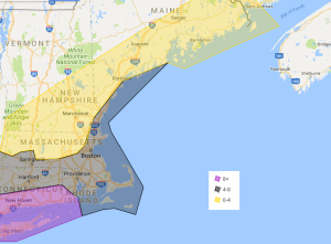
In the purple shaded areas 8 or more inches is likely and there could be pockets of up to 18 inches depending on snow banding in that region.  a general 4 to 8 inches  in the black shaded areas, expect the lower end of the amounts especially the further north you are and if your on the cape and islands. If there is mixing on the outer cape less than 4 inches can be expected. If it doesn’t mix it will likely be in the range. There could be some locally higher amounts in interior SE mass.  Due to the  dry air there will be a sharp cut off in snowfall. Areas in the yellow has a range of 0-4 because some where in this area will be the cut off. Again I could be dead wrong, there could be much more snow and this forecast busts but I truly believe that the dry air will play a huge part in limiting snowfall amounts especially across Northern Massachusetts.  Snow accumulation will be based on the heavier snow bands and tonight.

The coast will likely see light to moderate coastal flooding. Winds will be strongest along the coast and south of the pike with wind gusts in the 40s and 50s.

Forecast for the Merrimack Valley.

Today. Cloudy, with a chance of snow southern areas  late. Chance of flurries north  Highs in the lower 30s.

Tonight. snow south, snow showers likely north. Snow could be heavy at times south. lows in the upper 20s.  Breezy winds N at 10 to 20MPH with gusts in the 40s

Thursday. Snow likely in the morning then cloudy in the afternoon highs in the 30s.

Thursday night. Mostly cloudy, lows in the upper 10s to mid 20s.

Friday through Saturday mostly to partly cloudy highs in the 30s, lows in low to mid 20s

Sunday and Monday. Partly to mostly cloudy, highs in the mid 30s to low 40s. lows in the 20s.


Posted in forcasts and outlooks. | Leave a comment

March BLIZZARD

Major Nor-Easter is starting to form off the mid-Atlantic.  This storm will travel north/northeast while it strengthens and will dump heavy snow with strong winds. Sending Blizzard conditions across eastern New England. In order for it to be consider a blizzard you need the following criteria.

sustained Wind or frequent gusts of 35mph+

visibility less than 1/4 of a mile (white out conditions)

Both for three consecutive hours.

Blizzard conditions are likely any where in eastern new england but the areas that are most likely to see all three of the criteria met are those east of the red line.

Road conditions will be near impossible with snowfall rates of 1 to 3 inches an hour with the wind. Highest winds will be in the heavier snow bands and south and east.

on the left is the snowfall map. there is a wide swath of  one to two feet. Most in this area will find themselves in the 12 to 18 inch range, some being a bit lower, as it is highly dependent on where the snow bands form.  The best shot of seeing up to near 2 feet is in southeast mass. Those in the red will experience 6 to 12 inches, some higher amounts some lower amounts. Lower amounts in the CT river valley and the further northwest you go. Higher amounts in the higher terrain. In the Berkshires like the last storm could see moisture build up and bands forming in a favorable position to give this area more snow than surrounding areas in the terms of 10 to 18 inches of powder.

timing. Rain and snow showers over spread the region this evening from south to north. The heavy stuff starts after midnight for the Merrimack Valley. Snow ends from southwest to northeast Tuesday evening.

Also another note a slight shift to the east or west can make a huge difference, especially in wind and snowfall.

Also, unlike that other major storm that was a rain event for most of us, with the tide issues, this will not be as bad as the tides are lower this time around. Despite this, Very strong wave activity will continue to batter the coastal areas with increased erosion.


There are signs of another nor’easter but one storm at a time.  March really has come in like a lion 🙂

Posted in forcasts and outlooks. | Leave a comment

Coastal storm vs Upper level low

Before we start talking about a storm that will be some where off the atlantic coast, lets talk about the weekend.  This weekend looks seasonal with partly to mostly sunny skies. Highs will be in the upper 30s to low 40s with Sunday being the warmest. Ski country will stay in the 30s, creating a great weekend for skiing.

A coastal storm will likely develop off the southeast coast/mid-atlantic coast. The later this happens the better the chance of a larger ocean storm across most of the I95 corridor. If its to early, it will be weaker and send well south and east of the region as an upper level low pressure interacts with this low and provide periods of snow showers across the region. Even if this storm stays far out and we get fringe effects, we can still have a good amount of beach erosion.  Stay tune as this will need to be watched but at the moment looks to stay far enough south and east that it does not give us a large hit.

Forecast for Merrimack Valley

Saturday and Sunday. Mostly to partly sunny, highs in the upper 30s to low 40s. Lows in the 20s.

Monday. Partly to mostly cloudy. highs in the 30s

Monday night. Cloudy, chance of snow, lows in the 20s. 

Tuesday. Cloudy, Chance of snow, highs in the 30s. 

Tuesday night. Mostly cloudy, chance of snow. lows in the mid to upper 20s.

Wednesday.  Partly sunny highs in the 30s.

Wednesday night, partly cloudy , lows in the mid to upper 20s

Thursday. Sunny highs in the mid 30s to low 40s.

Thursday night and Friday. partly cloudy, highs in the low 40s. lows in the mid to upper 20s.


bold=  means low certainty.

Posted in forcasts and outlooks. | Leave a comment

Wet snow, ski areas rejoice

Ski areas woke up today with feet of new snow, some areas like Okemo got around 2 feet of fresh powder.  An extremely heavy snow band formed over the Berkshires up into Vermont. .  Around these parts, it was a heavy paste like snow, good for snowmen and snowball fights. Snow continued in light to moderate bands through morning as the storm continued its northerly movement. The storm will likely continue to spin some rain and snow showers through this evening across most of New England. heavy snow is still occurring in parts of Maine. The mountains are still seeing snow showers including the Berkshires at times. This looks to continue through this evening with scattered light snow showers. No accumulation from these though.  A chance of snow showers persist for friday as well as the upper level low pressure is over the region.

Our eyes turn to another storm system for monday/Tuesday time frame. This storm has a potential to be a decent hit, but most of the guidance shows it moving to the south do to the upper level low blocking it from coming up. If the low Moves east and north quick enough, the storm can come into the region, if not, the storm moves out to sea. We will likely get a better understanding of this storm coming Friday night/Saturday morning when all the pieces of the puzzle are over the continent.

Forecast for the Merrimack Valley

Tonight.  Chance of snow showers, Partly to mostly cloudy, lows in the low to mid 20s.

Friday. Mostly to partly cloudy chance of snow showers in the afternoon. highs in the 30s.

Friday night. Cloudy, chance of snow showers in the evening, lows in the upper 20s.

Saturday and Sunday. Mostly to partly sunny, highs in the upper 30s to low 40s.

Sunday night. Increasing clouds, lows in the low to mid 20s.

Monday Becoming mostly cloudy, highs in the 30s.

Monday night  through Tuesday night. Chance of snow showers. highs in the 30s, lows in the upper 20s.

Wednesday. partly to mostly sunny, highs in the 30s.

Wednesday night. Becoming cloudy, chance of snow showers lows in the 20s.

Thursday. Mostly to partly cloudy chance of snow and rain showers, highs in the 30s

Bold: show possible system effecting the region. Low confidence.

Posted in forcasts and outlooks. | Leave a comment

Storm update

Tricky Forecast for Eastern Massachusetts trying to determine the rain and snow line. I been burnt more than once changing my forecast the day of the winter storm. I am going to keep my snowfall forecast rather the same. BUT, the area within the red circle is still very dependent on where that snow/rain line forms. IF the rain line makes it to I95 this is the forecast. If its further south increase the amounts further south and east. If its further North and west shrink the black region in the northern section and send the 10+ outside of 495. The, areas in the green expect no snow accumulation. Areas in the black shaded areas, expect the higher end northern sections of the area, with Lessor amounts to the southern and eastern sections of this zone.  this is due to a wide range of factors, low snow ratio’s and the rain/ snow line possibly making it up to this area. In the 10+ zone areas in Northeast Mass can have a little less if the snow/rain line makes it further north than currently predicted.  Areas in the yellow shaded areas have the best chance of the higher snowfall amounts up to  2 feet of snow.

Timing.snow and rain showers move over the region in the morning and early afternoon Precipitation does not get heavy until Mid to late afternoon. snow changes quickly to rain across the regions shaded in green.


Despite this not being as windy as the last storm we had, power outages are likely in some locations. Especially areas where they have the heavy wet snow and the gustier winds. Some people will experience Blizzard like conditions for a time Wednesday night. Best shot of seeing these conditions will be Northeast Mass up into down east Maine. This is track dependent. The part of the blizzard criteria that will likely not be met is the 3 hour long requirement.  Wind gusts in the 30s and 40s in the interior with 50s and 60s in coastal areas.

Road conditions will be level 4 out of 5 in the read, with areas in the orange being in the 3 out of 5 range.  With the rest being in the range of 2. Not due to snowfall but do to the heavy rain, and breezy conditions.

Ski areas rejoice, with confidence, I say you will get hit by a very good snow storm.

Posted in forcasts and outlooks. | Leave a comment

You thought winter was done, Think again.

Many woke up this morning with a coating of snow on the ground, most of which has since seen it melt away under the high March sun. Don’t worry there is another storm that looks to blanket many under snow.  But first to look back at the Nor’Easter we experienced last week. It had major coastal concerns with wind gusts in the 60 to 90 range.  Many people lost power not due to snow but due to the wind.  It was a story of two storms. One of heavy wet snow well inland around the Berkshires, VT and NY. Even the  NYC area got some snow out of it.  Many along the coast of Massachusetts is still cleaning up and many communities still have people without power.  The coast is still feeling the affects from the last storm.

Now onto this next system. This storm will have a lot more colder air to work with. Its not cold as in this past early winter, but cold enough for snow.  Snow and rain will break out Wednesday morning and will become heavy in the afternoon and Wednesday night. Snow looks to continue through the first part of Thursday before ending. Most of the snow accumulation will happen Late afternoon through Wednesday night. There will be a rain and snow line and it will be rather stationary in one place.   Ski areas are rejoicing after a hard February, maintaining snow depth, March is roaring with snow chances through the middle of the month.

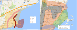
On the left  is the first  snowfall forecast.  On the right is the first road condition map prediction.

We will make up for the snow we did not get in the last storm. Most in the interior will see 10 or more inches of snow. Some will see less but many look to get much more than 10 inches. The areas in the yellow have the best shot of the heavier snowfall.  Some models show up to two feet in portions of ski country.  The area in the red circle as typical for nor’easters is in question with the snow and rain line. For now the snow and rain line, is predicted to make it to around  I95. This line might not make it pass Boston at all or make it to 495. If it makes it to 495 much less snow in the region in red. Further south and east more snow.  Also with this storm where its snow its snow. There will be a sharp snow gradient ( for example Boston, one side of town has 2 inches the other side have 12 inches.) Snowfall rates of 1 to 4 inches is possible. The storm will be strengthening as it passes the region.

Road conditions, will be the worst Wednesday mid afternoon through Thursday early morning. Commutes that will be most impacted will be Wednesday evening and Thursday morning with moderate delays Wednesday afternoon.  Road conditions of 4 out of 5 is anticipated in the red, with level 3 and 4 out of 5 road conditions in the orange with level 2 road conditions in the region shaded in yellow.  Due to the previous storm’s impacts there is still many obstacles in roads especially along the coast.


Despite this not having as much wind involved, Wind gusts in the  60s are possible along the coast. With wind gusts of 30 to 60 across the interior, especially the higher terrain.  Blizzard like conditions could form especially across northern Massachusetts up into NH and down east Maine. At this time Blizzard criteria being met of blizzard conditions for 3 or more hours is unlikely but will be monitored. Also with the snow being involved with the wind, can cause power outages.  I am hope everyone gets their power before this storm happens.

Next update late tonight or tomorrow


Another thing we are looking at is that the water table is in very good shape this year, with the amount of water we have had in the form of rain and snow, we are in rather good shape. With this next storm we are getting another 1 to 2.5 inches of water.


Posted in forcasts and outlooks. | Leave a comment

March Madness?

Many people been getting out the t-shirts, shorts and I have even seen some flip flops out. I hope this storm has reminded you this is New England. Many experienced heavy rain and strong winds. There is a major difference to our west in the Berkshires and NY state up into VT where near a foot of heavy wet snow has fallen. Winds will continue to howl through tonight and will slowly go down Saturday morning. As the storm continues to pull away Precipitation will end from North to Southeast. As this happens rain could change to snow. There will be a chance of rain and snow showers through the weekend This weekend  we will see temperatures in the 30s. More typical for this time of year.  Skies will finally clear Sunday.  For the week ahead, Monday and Tuesday look quiet with temperatures in the mid-30s to low 40s. A storm system looks to take aim at the region during the middle  to late part of the week. This storm looks to have more cold air to work with and looks snowier at the moment. More details as we get closer but we have  entered a more favorable pattern for snow chances through the first half of March.

Tonight. Periods of rain and snow. Ending North to south. West to east.  lows in the 30s. Very windy.

Saturday through Sunday. Windy, Chance of rain and snow showers. Partly to mostly cloudy.  Highs in the 30s.

Sunday night. Decreasing clouds,  lows in the 20s.

Monday and Monday night, partly cloudy, highs in the mid 30s to low 40s.

Tuesday. Partly cloudy, highs in the upper 30s to low 40s.

Tuesday night. Increasing clouds, lows in the 20s

Wednesday. Cloudy chance of snow and rain, highs in the 30s.

Wednesday night. cloudy, chance of snow lows in the 20s. Mostly cloudy

Thursday. cloudy chance of snow. highs in the 30s. Mostly cloudy.

Thursday night through Friday. Partly cloudy highs in the upper 30s to mid 40s. Lows in the 20s to low 30s.

Posted in forcasts and outlooks. | Leave a comment

Mother Nature’s take’s aim with 975 Monster

Hoped you enjoyed your quiet February because the Lion is waking up  March. Major Storm to develop with Damaging winds, severe Coastal concerns and flooding rains.

Winds start to pick up pre_dawn Friday and quickly intensify. Strong winds last through Friday night into Saturday morning based on the 00z nam

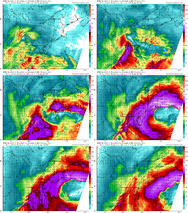
Winds: Winds will be a major aspect of this storm. Winds will be gusting over 50 mph over western and central mass, Over 60 mph across eastern mass and over 70 mph over parts of Northeast mass, coastal areas Cape and islands. Sustain winds will be between 20 to 45 mph across Eastern and central Massachusetts. With highest across Eastern Mass.  Unlike usual storms with sustain winds being strongest along the coast, these winds can be strong rather far inland as well.  Above you are looking at the 00z nam 850 winds. The strongest are within the purple and the more whiter shades are the stronger winds. you see the these patches of stronger winds moving east to west with the strongest winds of course along the coast but also traveling well inland before weakening their punch.

Coastal concerns Severe coastal flooding and erosion is anticipated. water levels of around 15 to 16 feet are anticipated which matches or goes over the January 4 storm this past January. That saw many low lying areas being flooded. If you had water then expect water this time as well. Possibly higher so those that were close also anticipate water. Wins will also add with very large waves of 20+ feet off the coast. Mariners get yourself to safe harbor. You will probably be stuck in the harbor till Monday or Tuesday of next week

Total precipitation amounts of 1 to 4 inches are possible most going at least over 2 inches of precipitation with the Highest being over Southeast Mass or portions of northeast Mass. Due to the lack of active tree/plant life sucking water up, this could lead to river flooding or nearing their banks. The heavy rain will also lead to street flooding.


. The best chance of moderate to heavy snowfall is across the Berkshires as well as the higher elevations of central mass. The snowfall forecast has a high bust potential. You will get either a lot of snow or very little. Everything needs to line up just right for us to get snow out of this type of storm. This storm is not tapping into a nice cold high pressure to the north like our usual nor- Easters, if this storm happened a few weeks ago we would be talking about an epic Blizzard but we are not. What ever happens with the snow, the main concern with this storm will be on the coast with possible records being broken. Winds will also be another story with wind gusts of up to 70 being possible all the way to the 495 belt.  The worst of the winds will happen Friday mid afternoon through Friday evening. Update will happen by facebook and through the blog through tomorrow and throughout the storm. With this storm if snowfall does happen it will be a heavy wet snow and with any wind with it, power outages are likely. Power outages are likely even if you have no snow.


Today. Increasing clouds, highs in the 50s.

Thursday night. Rain developing becoming breezy, lows in the 30s.

Friday. Very windy, Heavy rain possibly changing to or mixing with snow late.  highs in the low 40s.

Friday night. Cloudy. Mix of snow and rain., Very windy. temperatures dropping into the 30s.

Saturday. chance of snow and rain in the morning. Windy. highs in the 30s.  mostly cloudy.

Saturday night to Sunday night. Partly to mostly cloudy highs in the 30s, lows in the mid to upper 20s.

Monday through Tuesday Mostly sunny highs in the upper 30s to mid 40s. lows in the mid to upper 20s.

Tuesday night increasing clouds, lows in the 20s.

Wednesday. cloudy chance of snow and or rain. Highs in the 30s.


Posted in forcasts and outlooks. | Leave a comment