
Hoped you enjoyed your quiet February because the Lion is waking up March. Major Storm to develop with Damaging winds, severe Coastal concerns and flooding rains.
Winds start to pick up pre_dawn Friday and quickly intensify. Strong winds last through Friday night into Saturday morning based on the 00z nam
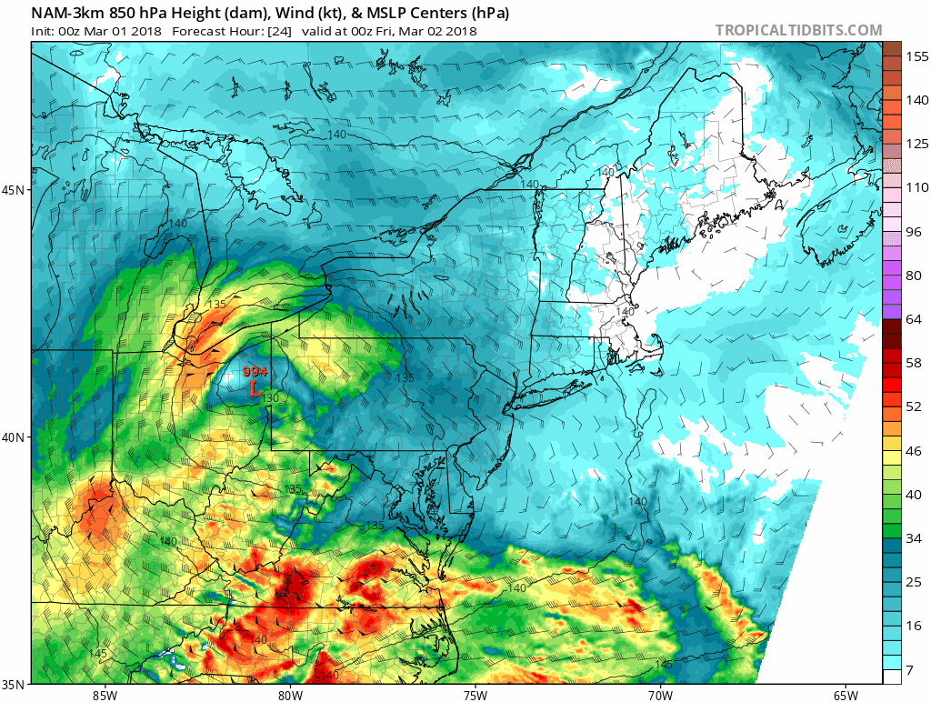
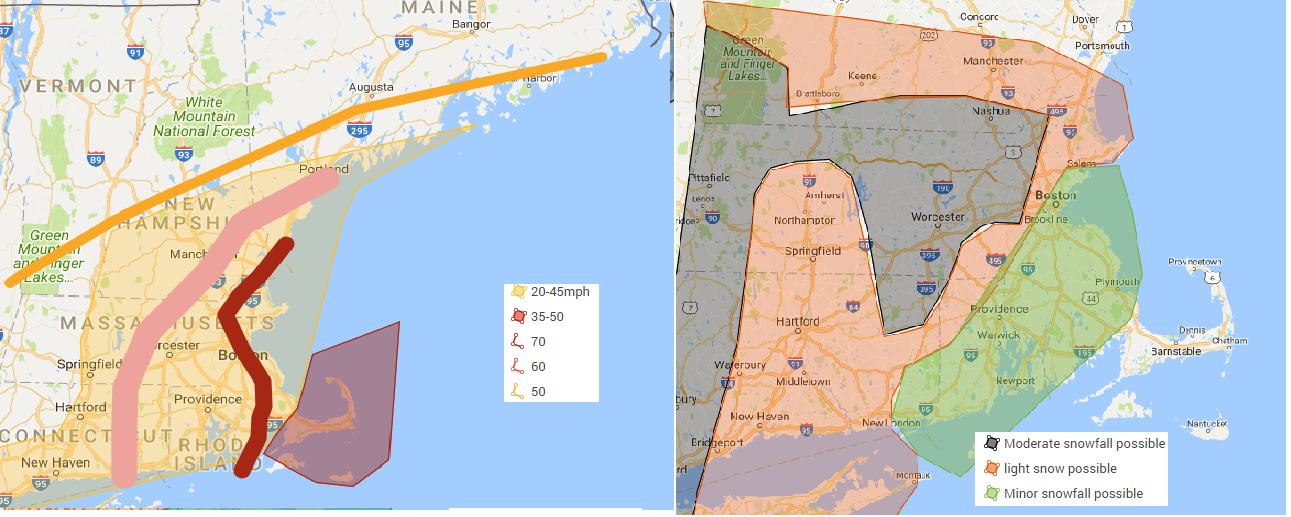
Winds: Winds will be a major aspect of this storm. Winds will be gusting over 50 mph over western and central mass, Over 60 mph across eastern mass and over 70 mph over parts of Northeast mass, coastal areas Cape and islands. Sustain winds will be between 20 to 45 mph across Eastern and central Massachusetts. With highest across Eastern Mass. Unlike usual storms with sustain winds being strongest along the coast, these winds can be strong rather far inland as well. Above you are looking at the 00z nam 850 winds. The strongest are within the purple and the more whiter shades are the stronger winds. you see the these patches of stronger winds moving east to west with the strongest winds of course along the coast but also traveling well inland before weakening their punch.
Coastal concerns Severe coastal flooding and erosion is anticipated. water levels of around 15 to 16 feet are anticipated which matches or goes over the January 4 storm this past January. That saw many low lying areas being flooded. If you had water then expect water this time as well. Possibly higher so those that were close also anticipate water. Wins will also add with very large waves of 20+ feet off the coast. Mariners get yourself to safe harbor. You will probably be stuck in the harbor till Monday or Tuesday of next week
Total precipitation amounts of 1 to 4 inches are possible most going at least over 2 inches of precipitation with the Highest being over Southeast Mass or portions of northeast Mass. Due to the lack of active tree/plant life sucking water up, this could lead to river flooding or nearing their banks. The heavy rain will also lead to street flooding.
. The best chance of moderate to heavy snowfall is across the Berkshires as well as the higher elevations of central mass. The snowfall forecast has a high bust potential. You will get either a lot of snow or very little. Everything needs to line up just right for us to get snow out of this type of storm. This storm is not tapping into a nice cold high pressure to the north like our usual nor- Easters, if this storm happened a few weeks ago we would be talking about an epic Blizzard but we are not. What ever happens with the snow, the main concern with this storm will be on the coast with possible records being broken. Winds will also be another story with wind gusts of up to 70 being possible all the way to the 495 belt. The worst of the winds will happen Friday mid afternoon through Friday evening. Update will happen by facebook and through the blog through tomorrow and throughout the storm. With this storm if snowfall does happen it will be a heavy wet snow and with any wind with it, power outages are likely. Power outages are likely even if you have no snow.
Today. Increasing clouds, highs in the 50s.
Thursday night. Rain developing becoming breezy, lows in the 30s.
Friday. Very windy, Heavy rain possibly changing to or mixing with snow late. highs in the low 40s.
Friday night. Cloudy. Mix of snow and rain., Very windy. temperatures dropping into the 30s.
Saturday. chance of snow and rain in the morning. Windy. highs in the 30s. mostly cloudy.
Saturday night to Sunday night. Partly to mostly cloudy highs in the 30s, lows in the mid to upper 20s.
Monday through Tuesday Mostly sunny highs in the upper 30s to mid 40s. lows in the mid to upper 20s.
Tuesday night increasing clouds, lows in the 20s.
Wednesday. cloudy chance of snow and or rain. Highs in the 30s.
