February Roller coaster.

The past week has seen temperatures in the 50s, snow, rain, name the season and you probably experienced it….. Just kidding its February.  We saw many high temperature records today broken. We could see this again tomorrow. This extreme warmth for Febuary is due to a ridge of high pressure, thats rare to say the least for this time of year. The upper air pattern is like that of late spring, but with the cold air around to the north we will not get that warm. But, temperatures look to range again in the 60s tomorrow and possibly low 70s in some locations. A cold front will move through Wednesday night with a chance of rain. A weak area of low pressure will likely form and send a period of snow to the region Thursday afternoon but not expecting much. Another period of rain could form for Friday depending on the location of the high pressure across the southeast.

Forecast.

Wednesday: Partly cloudy, highs in the 60s.

Wednesday night. Increasing clouds, chance of showers late. lows in the 30s.

Thursday. chance of rain and snow showers early then snow likely. highs in the low to mid 30s. Temperatures dropping afternoon.

Thursday night.  Chance of snow showers, partly cloudy lows in the 10s to low 20s.

Friday. Partly to mostly cloudy warmer highs in the upper 30s to low 40s. chance of rain/snow late.

Friday night. rain likely south, rain likely with a chance of snow north. lows in the 30s

Saturday.  mostly to partly cloudy highs in the upper 30s to low 40s.

Saturday night.  Cloudy chance of rain, sleet and snow showers late. lows in the 30s.

Sunday. Cloudy, Chance of rain, sleet and snow showers highs in the 30s.

Sunday night.  cloudy chance of rain and snow showers.

Monday through Tuesday. Partly cloudy  highs in the 40s.


there are some good signs that this warmth will be short lived and will be replaced by a colder pattern, not great for snow, but better than it has been all of February for the first half of March into college spring breaks. February is usually  one of our snowier months of the year, maybe we can have winter go out with a bang this March.


Posted in forcasts and outlooks. | Leave a comment

Ski country looks to score

Ski country is going to be getting much needed snow within the next week as a more active weather pattern has taken shape. First up, Storm number 1, An area of low pressure will form along the spine of the Appalachians, sending a messy storm to southern New England with snow, sleet, freezing rain and rain. Ski country should remain all snow. In our area, Precipitation will move in from the west in the late morning Wednesday and will become heavy rather quickly, going through the evening commute, as this happens, the rain line will be moving north, changing most south of the pike to rain including Boston.  In the area along and north of the mass pike to the Massachusetts Border and West of I95, up to a quarter inch of ice could form depending on track of storm and how quick the change over to rain happens compared to the lower levels warming.

Snowfall forecast left, road conditions right. Worst road conditions for those south of the pike will be late morning to mid afternoon. Areas north of the Pike, will see poor road conditions Wednesday afternoon and evening before tapering off.

Another area of low pressure could take aim at the region this weekend.

Forecast for the Merrimack

Tuesday: Cloudy then clearing. highs in the upper 20s to low 30s. Chance of snow showers/flurries in the morning.

Tuesday night. Becoming Partly cloudy, lows in the 10s

Wednesday. Snow developing, snow can be heavy in the afternoon. Chance of sleet late highs in the upper 20s to low 30s.

Wednesday night. cloudy, Snow north, mix of snow, sleet, freezing rain and rain south, Precipitation ending southwest to northeast. lows in the 20s

Thursday. clearing, highs in the upper 20s.

Thursday night.  clear, lows in the 10s.

Friday. Becoming cloudy, highs in the mid to upper 20s.

Friday night. Cloudy chance of snow, lows in the 10s.

Saturday. Partly to mostly cloudy, highs in the 30s.

Saturday night. Cloudy chance of snow, sleet, freezing rain and rain. lows in the 20s.

Sunday. Cloudy chance of snow, sleet, freezing rain and rain. highs in the 30s

Sunday night. cloudy chance of snow, sleet, freezing rain and rain, lows in the upper 20s to low 30s.

Monday, Becoming sunny, highs in the upper 20s to mid 30s.


Posted in forcasts and outlooks. | Leave a comment

More Active Weather Pattern

A start of a more active weather pattern is on tap for the region with a few storm systems that look to take aim at the region.  Sources of Cold air have been trapped in Canada for the past several weeks, and will likely dip into the region after storm systems move in, but a southeast ridge looks to keep any cold shots rather short lived.

There will be an increase in clouds tonight into tomorrow morning ahead of our next system. The first batch will occur sometime in the morning with a period of a light mix of snow/sleet/freezing rain and rain. The main event will be occurring when the super bowl is happening, rain will over spread the region from southwest to northeast and will become heavy at times. Most of the rain should end before day break besides for northern areas where showers will persist through morning.

The pattern is going to be fast moving, with an area of high pressure taking control of the region for Monday with sunny skies this will quickly move east of the region,  An other area of low pressure that looks to form over the Plains will move east northeast spreading the chance of snow and rain to the region. More details on this possibility once we get closer to it.

Forecast for the Merrimack Valley

Tonight. Increasing clouds, lows in the upper 10s to low 20s

Sunday. Cloudy, chance of morning light mix. Rain developing late. Highs in the upper 30s

Sunday night. Cloudy, Periods of rain mixing with snow late possible before ending.

Monday. Becoming sunny highs in the 30s.

Monday night. Increasing clouds, lows in the 20s

Tuesday.  Partly to mostly cloudy chance of snow showers/flurries highs in the upper 20s to low 30s.

Tuesday night Cloudy chance of snow, lows in the 20s

Wednesday. Cloudy chance of snow and rain highs in the 30s.

Wednesday night. cloudy chance of snow and rain. lows in the upper 20s

Thursday. cloudy chance of snow and rain. highs in the 30s.

Thursday night. clear, lows in the 10s

Friday Friday night. Mostly sunny highs in the upper 20s to low 30s. Lows in the 10s

Saturday. Sunny to partly cloudy, highs in the upper 20s to mid 30s.

The forecast passed this weekend will experience changes to it as models been crappy for a while.


Posted in forcasts and outlooks. | Leave a comment

Up and down continue

We will be watching a weak area of low pressure, moving across the northern tier of the country, this will send some snow Tuesday night into Wednesday, temperatures will around 30. Not expecting any type of blockbuster storm, but the timing of the event is the problem as it will likely impact the Wednesday morning commute. ‘

A general swath of 2-5 inches of snow (purple). Within this area some locations will see higher amounts do to mid level atmospheric dynamics, but where is sweat spot forms is difficult to pin point.  Expect the lower end of the range as in general the snow should be light.

A warm up is expected following the system with highs in the 40s for the weekend.

It won’t take much for the colder air up in Canada to move down into the region, at the moment warmer pacific Air looks to dominate the Lower 48, limiting the length of any real cold.

Forecast of the Merrimack Valley

Tuesday. Mostly cloudy, highs in the mid to upper 20s

Tuesday night. Periods of snow developing west to east. South to North after midnight. Cloudy, lows in the 20s.

Wednesday. Cloudy periods of snow, Snow ending late. Highs in the upper 20s to low 30s.

Wednesday night.  Cloudy, chance of snow showers early. lows in the 10s

Thursday through Friday. Mostly sunny to partly cloudy, highs in the 30s, lows in the 20s

Saturday and Sunday, Partly cloudy during the days, cloudy at night, highs in the 30s but upper 30s to low 40s south.  Lows in the upper 20s.


Posted in forcasts and outlooks. | Leave a comment

Cold Miser and heat Miser at it again.

An elongated area of low pressure will send periods of heavy rain with embedded thunderstorms through tonight, a cold front will approach from the northwest and allow for colder air to move into the region. Ski country looks to get 4-8 inches of snow with 0-4 in the valleys. There will likely be areas of central and Northern New England that experience up to a half inch of ice. In the Merrimack Valley expect temperatures to drop tomorrow morning. Highs will occur pre-dawn hours with highs in the 50s but will drop rapidly and be in the 20s by late morning and afternoon. The heaviest of precipitation should be ending for the lower sections of the valley in Northeast Massachusetts by the time this change from pure rain to freezing rain/sleet occurs. Looking ahead, temperatures look to remain in the 20s for the second half of the holiday weekend through the week.  We will have to monitor a chance of some snow showers Tuesday night into Wednesday as a quick moving clipper moves in from the northwest OR the energy involved with this clipper could interact with a piece of energy further south and give the region a good snowstorm Mid to late week but all the players need to be looked. There will be  a better understanding of this come Monday.

Forecast for the Merrimack Valley.

tonight. Heavy rain, rainfall around .75 to 2 inches. Areas of fog, breezy late.

Saturday. Areas of fog. Areas of Heavy rain changing to Freezing rain from Northwest to southeast. Highs in the low to mid 50s. Temperatures dropping into the 20s. Precipitation ending after noontime from southwest to Northeast.

Saturday night. Clear, cooler, flash freeze, lows in the singe digits.

Sunday. cooler, Mostly sunny, highs in the 10s

Sunday night. Clear, lows around zero

M.L.K day Sunny, highs in the 10s.

Monday night. clear, lows around zero to 5 above.

Tuesday. Some what warmer, highs in the mid to upper 20s.

Tuesday night. Increasing clouds, lows in the 10s.

Wednesday Partly to mostly cloudy, chance of snow, sleet and Rain showers highs in the upper 20s to low 30s.

Wednesday night through Thursday. chance of snow and sleet Highs in the upper 20s to mid 30s. Lows in the 20s.

Friday through Saturday. Mostly sunny, highs in the 20s, lows in the mid to upper 10s.


Posted in forcasts and outlooks. | Leave a comment

Not as cold but not as warm as they said.

Everyone been hearing about this warm up which is happening but that does not mean 50s and 60s.  Temperatures will be on the increase as the week goes on. Highs will be in the low to mid 30s Tuesday and Wednesday, then a front moves through Wednesday evening with a chance of some light freezing rain/sleet and snow showers. The second half of the week will be warmer but with a cost. There will be more clouds than sun going through the weekend. We will have to monitor the timing of different disturbances and colder air. I am leaning towards a cooler situation for the weekend. It looks at the moment that there will be a ridge to the south trying to push north with a colder air mass to the north tring to push south. If the colder air moves in quick enough it could push the low pressures to the south and east making a more snowier situation, if it takes longer, we could have a very ICE situation for interior new england while areas south of Boston sees 40s.

Tuesday. Mostly sunny to partly cloudy, highs in the low to mid 30s.

Tuesday night. Partly cloudy lows in the 10s

Wednesday, increasing clouds, highs in the mid 30s.

Wednesday night. Chance of rain showers, snow showers, sleet and freezing rain. lows in the 20s

Thursday. Mostly cloudy, much warmer highs in the upper 30s to mid 40s.

Thursday night. cloudy chance of rain and pockets of freezing rain, lows in the 30s

Friday. Rain likely, rain could be heavy at times. highs in the upper 30s to mid 40s.

Friday night.  cloudy chance of rain and sleet. lows in the 30s

Saturday. Mostly cloudy chance of rain/freezing rain, sleet and snow late. Highs in the 30s.

Saturday night. cloudy chance of snow, sleet, freezing rain and rain. lows in the 30s.

Sunday. cloudy chance of snow, sleet, freezing rain and rain, highs in the upper 20s to low 30s.

Sunday night. clear, cooler lows in the 20s.

Monday and Monday night. Cooler, highs in the upper 20s to low 30s, lows in the 10s.

the weekend forecast is likely to change multiple times as we will be dealing with temperature battles in the region.

Posted in forcasts and outlooks. | Leave a comment

Storm Update 4


What a magnificent storm. Look at the hook currently east of Virginia . Go to the link to get the greatness of the GOES 16.

http://weather.cod.edu/satrad/exper/?parms=continental-conus-02-48-0-100


Updated snow map, due to current short range models and radar, there is also some geography/geology  that goes into my snow maps.

In terms of snowfall, the 10+ area expanded southwestward do to banding as well as westward up in Maine. This area will be heavily influenced by banding. Some areas will barely make the 10 inch mark while others go well over around 18 inches. Some areas of Maine could be measuring up to two feet depending on exact track. the track of the storm of this strength does a little dance of the wobbles.

Basically all areas have seen an increase except the outer cape where 1-3 inches is anticipated.

The best chance for Blizzard criteria of 3 hours of sustained winds or gusts of 35+, white out conditions all being met is Coastal Maine, Coastal NH, Coastal southeast Mass portions of the cape depending on how long it takes for it to change to snow.

Blizzard conditions are possible as far west as the yellow line, especially with the heavier snow bands.

coastal concerns are of great concern.

Please stay off the road especially in Eastern New England today.

Posted in forcasts and outlooks. | Leave a comment

Storm update 3.

Large ocean storm moving up the east coast and will be going under something called bombogenisis. this is not a rare within itself. This storm looks to drop 40 MBs within a 24 hour which is over the 24MB drop that is needed to qualify.

Many models are showing around 960MB or lower as it takes its closest pass to cape cod. Still some what of a question on snowfall and exact track.


Timing. Snow develops 3am to 6am from south to north. Wind arrives with it rather quickly.

The worst of the storm will be 8am to 8pm a 12 hour window. This window will start and end later the further north you are.

Snowfall rates of 1 to 3 inches is possible in the heavier bands

Snowfall will be greatly influenced by banding features

Map on left. snowfall.

Purple 10 or more inches of snow but again some banding will have much higher amounts while others barely gets to 10 inches in this range.  The blue 5 -10 inches of snow but again with banding features. Red will see some mixing issues with the rain and snow line before the coastal front moves back to the east. Outer cape and the islands light snowfall is anticipated as the storm pulls away.

Expect the lower end of your amounts but remember the higher end is also possible..

Road conditions. Map on the right.  these are influenced by snow, ice wind and visibility.

Level 5 road conditions in the dark red. Please avoid travel especially after 8am.

Level 4/5 areas of level 4 and level 5 driving conditions in orange.

Level 3 driving areas in purple.

Level 2 driving conditions in gray.

Middle map.

Blizzard warning east of red line. There is a chance of  Near white out conditions due to blow and falling snow, sustained winds or wind gusts over 35mph and for three hours. ( officially called a blizzard if of these occur) Blizzard conditions likely.

Blizzard watch east of yellow lone, Chance to likely hood of blizzard conditions along and east of the line.

Winter weather warning in pink.

Winter weathe advisory in Purple.

All areas could be under a high wind advisory Thursday night through Friday as winds will remain gusty behind the storm with arctic air rushing in.


Posted in forcasts and outlooks. | Leave a comment

Storm Update 2.

Powerful Nor-Easter traveling up the east coast. This storm will effect the coastal areas from Florida to Maine.  Parts of Northern Florida and parts of Georgia is experiencing an major ice storm with ice of up to  half of an inch. That is a major ice storm even for New England standards. (PS can not wait to see the pictures). There are winter storm headlines up and down the entire east coast by the National Weather Service. (NOAA) Mid-atlantic states, some eastern locations could have blizzard conditions.

Now to our area.

When. Late tonight through Thursday Night.

The Nor-Easter will be strengthening as it heads up the east coast and will likely be around 960MBs, powerful storm but not unheard of. Models show lower MBs and higher MBs.

Snowfall

Snowfall forecast is not of high confidence specially. ( this will likely be updated a few times today/evening but only if I see it being warranted)

Expect the lower end of your snowfall range unless you are in the banding locations, which will be better handled later this afternoon/evening. Snowfall rates of 1+ is anticipated.

Snow. of 5-10 inches. RI. Portions of interior southeast Mass, Eastern Mass, Southeast NH and areas of Maine along and east of I95.  Locally higher amounts are possible, especially in eastern Maine.

Blizzard Conditions


Dark red Blizzard criteria could be met. Pink line, Blizzard conditions likely east of Line. Orange, chance of Blizzard conditions along and east of line.

Blizzard conditions are likely in Eastern New England with the best chance of blizzard conditions being met east of the red lines. Coastal southeast Mass, Coastal Northeast Mass, southeast NH and Coastal areas of Maine.

Wind will be of high concern with this storm but again not unheard of for around here. Winds of 25-40 MPH across Eastern New England with gusts up to 70. Highest of course will be around the coastal areas.

Blizzard conditions are likely along and east of I95 with the best chance of the Blizzard criteria being met. That is three hours of whiteout conditions, Sustained wind or continuous gusts of 35mph+ Being North shore, southern NH and Coastal areas of Maine. Areas of southeast mass cape and Islands could be dealing with a snow/rain line. The chance for Blizzard criteria being met on the southeast coast could go out the window,

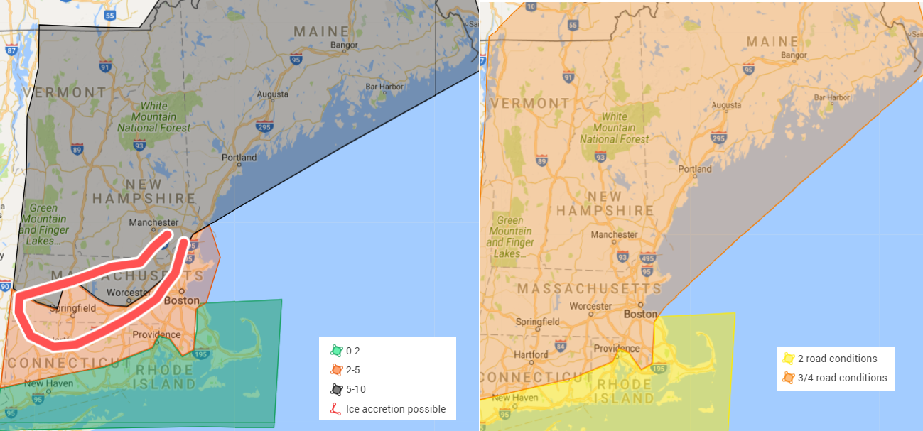
Road conditions Warnings/watches/advisories

Map on left.

Road conditions, Level 5 road conditions are anticipated for coastal maine, coastal NH, Coastal Northeast Mass to Boston to south shore.  Level 4 to level 5 road conditions in the orange with visibility of less less than 1/4 quarter at times with falling and blowing snow. With 1-3 inch snowfall rates.  Cape cod and the islands road conditions will be poor all day but during the late afternoon/evening will likely change back to snow causing for near blizzard conditions which is why they are in this range. Another factor going into this is wind. High profile vehicles should stay off the road. .

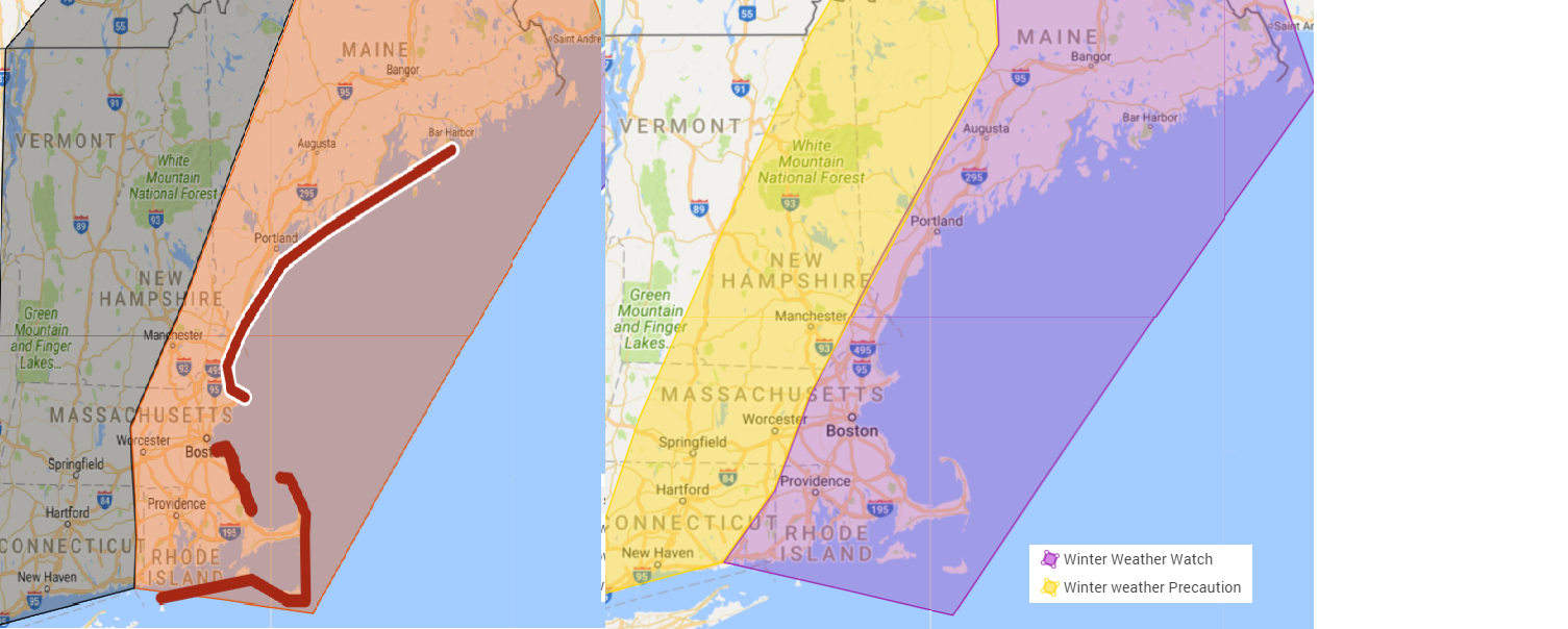
Map on the right. Warnings/ watches and advisories. concerns.

Blizzard warning for coastal New England. Areas east of red line.  Best chance for Blizzard criteria Coastal maine to coastal Northeast Mass. With the south shore and cape also having a good chance at seeing all criteria met particularly in the afternoon/evening once the change over back to snow occurs.

Blizzard watch: which is based on the Blizzard watch that Noaa use to use is east of the yellow line. This means there is a chance for all blizzard criteria to be met.  chance/ likely hood of blizzard conditions.

Winter weather warning in red. with Winter weather advisory in  grey.

high wind warning for cape cod and the islands.

Coastal residence should be prepared for major coastal erosion and coastal flooding with this storm. Please prepare now. Main threat is tomorrow afternoons high tide. Areas of most concern is Coastal Maine, Northeast mass and outer cape cod.

Please continue to monitor future forecast. Update will come this evening, when new data comes in and we get in range of more mesoscale weather models.  This storm could come in further west or further east, but will have a better handle of it this evening. This storm will be moving rather quickly so the worst of it for southern New England will be 8/9am to 5/6 pm. With the storm moving north/Northeast winds will continue to howl and advisory level winds will continue for Friday. Temps will plummet and be even colder than the last arctic blast.


Posted in forcasts and outlooks. | Leave a comment

Storm update

First of several storm updates.

When. Wednesday night through Thursday night.

A large winter storm will be developing off the east coast, sending strong winds, moderate snow to portions of the region and near white out conditions possible. Wind chills will be around zero for many. There will also be coastal concerns do to the high winds and surf. Coastal erosion is likely at this time.

Unknowns. Exact track is still somewhat unknown and will get a better handle on it as today progresses and especially this evening. A further track east will limit any snowfall, and lesson the effects of wind and coastal concerns. The coastal concerns are likely though even with a further east track.  The storm could also track further west increasing snowfall for Eastern New England, Increasing winds and

First snowfall map. ( Range map) Numbers will be added tonight/tomorrow due to uncertainty.


Watches/Precautions

Map on the left map High wind watch. cape cod and the Islands, Rode Island, Southeast CT, Eastern Massachusetts, Southeast NH, Eastern Maine. (red) Wednesday night through Friday morning

High wind precaution Central Mass, NH, Interior Maine.  Wednesday night through Thursday night

Highest risk for coastal concerns redlines Wednesday night through Friday morning

Map on right: Winter weather watch Eastern New england Purple Wednesday night through Thursday night

yellow/ Interior Southern new England Interior NH and parts of southwest Maine. Wednesday night through Thursday night.

Temperatures in the 10s and 20s but 20s and 30s southeast coast possible. Snow/rain mix cape and Islands.

Side note. Blizzard conditions are likely especially across areas along and east of I95 Southeast mass, eastern Mass, southern NH Eastern Maine and Northern Maine.

Please monitor for future updates from here and your other trusted weather sources. This storm looks to be a beast of a storm, its the matter of how close it is to the coast.


Posted in forcasts and outlooks. | Leave a comment