Many woke up this morning with a coating of snow on the ground, most of which has since seen it melt away under the high March sun. Don’t worry there is another storm that looks to blanket many under snow. But first to look back at the Nor’Easter we experienced last week. It had major coastal concerns with wind gusts in the 60 to 90 range. Many people lost power not due to snow but due to the wind. It was a story of two storms. One of heavy wet snow well inland around the Berkshires, VT and NY. Even the NYC area got some snow out of it. Many along the coast of Massachusetts is still cleaning up and many communities still have people without power. The coast is still feeling the affects from the last storm.
Now onto this next system. This storm will have a lot more colder air to work with. Its not cold as in this past early winter, but cold enough for snow. Snow and rain will break out Wednesday morning and will become heavy in the afternoon and Wednesday night. Snow looks to continue through the first part of Thursday before ending. Most of the snow accumulation will happen Late afternoon through Wednesday night. There will be a rain and snow line and it will be rather stationary in one place. Ski areas are rejoicing after a hard February, maintaining snow depth, March is roaring with snow chances through the middle of the month.
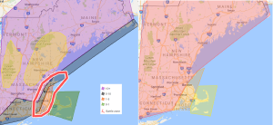
On the left is the first snowfall forecast. On the right is the first road condition map prediction.
We will make up for the snow we did not get in the last storm. Most in the interior will see 10 or more inches of snow. Some will see less but many look to get much more than 10 inches. The areas in the yellow have the best shot of the heavier snowfall. Some models show up to two feet in portions of ski country. The area in the red circle as typical for nor’easters is in question with the snow and rain line. For now the snow and rain line, is predicted to make it to around I95. This line might not make it pass Boston at all or make it to 495. If it makes it to 495 much less snow in the region in red. Further south and east more snow. Also with this storm where its snow its snow. There will be a sharp snow gradient ( for example Boston, one side of town has 2 inches the other side have 12 inches.) Snowfall rates of 1 to 4 inches is possible. The storm will be strengthening as it passes the region.
Road conditions, will be the worst Wednesday mid afternoon through Thursday early morning. Commutes that will be most impacted will be Wednesday evening and Thursday morning with moderate delays Wednesday afternoon. Road conditions of 4 out of 5 is anticipated in the red, with level 3 and 4 out of 5 road conditions in the orange with level 2 road conditions in the region shaded in yellow. Due to the previous storm’s impacts there is still many obstacles in roads especially along the coast.
Despite this not having as much wind involved, Wind gusts in the 60s are possible along the coast. With wind gusts of 30 to 60 across the interior, especially the higher terrain. Blizzard like conditions could form especially across northern Massachusetts up into NH and down east Maine. At this time Blizzard criteria being met of blizzard conditions for 3 or more hours is unlikely but will be monitored. Also with the snow being involved with the wind, can cause power outages. I am hope everyone gets their power before this storm happens.
Next update late tonight or tomorrow
Another thing we are looking at is that the water table is in very good shape this year, with the amount of water we have had in the form of rain and snow, we are in rather good shape. With this next storm we are getting another 1 to 2.5 inches of water.

