
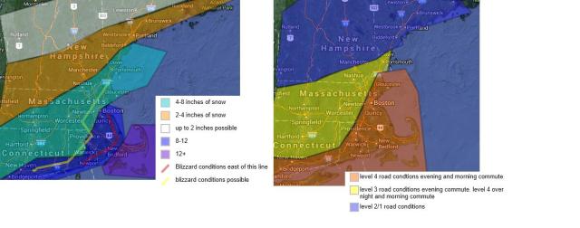
Today will feature mostly cloudy skies as a storm system approaches from the south/southwest. Snow will start to break out across the region from southwest to northeast starting around noon time.. They heavy snow will not start till late afternoon. Blizzard conditions are likly across eastern and southern plymouth counties , cape and islands. Blizzard conditions are possible as far west as 495. Visibilites will be greatly reduced with a lot of cold air this snow will be fluffy and easily picked up by the wind. Winds could gusts to 45 mph across eastern massachusetts tonight and early wednesday. Snow will end from west to east. snow should end around 1pm for most. Wind chills will be as low as 15 below with actual low temperatures reaching zero or going below zero. another possible system is possible over the weekend though does not look strong and looks to go further out to sea. Will have updates this afternoon
Today. becoming cloudy snow developing late, becoming windy. highs in the upper 10s
tonight. snow, lows in the upper single digits . very windy. wind chills as low as 10 below
Wednesday. mostly cloudy snow ending. highest amounts south and east., windy areas of blowing and drifting snow. cold. highs in the low to mid 10s. wind chills as low as 10 below
Wednesday night. partly cloudy. cold. lows 5 below to 5 above zero. wind chills as low as minus 15
Thursday through Friday. mostly sunny highs in the low to mid 10s. lows around zero
Friday night. increasing clouds, lows around zero
Saturday. mostly cloudy chance of snow showers. highs in the upper 20s
Saturday night.mostly cloudy chance of snow showers. lows in the lower 10s
Sunday through Monday. partly sunny highs in the lower 20s, lows in the low 10s
