
As an arctic front moved through today and during tonight an area of low pressure will start to form and move up along it. This forecast has huge bust potential, We need to look at the placement of the arctic front. There will be no rain issues with this system. One thing for certain is that we get the wind and major wind chills. highs might not hit 20 for 3 days.
If my current thinking stands.
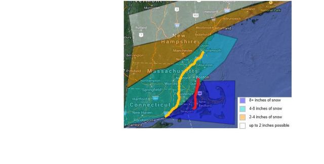
Snow will start out early tomorrow afternoon rather light and spread from southwest to northeast. the heavier snow will fall from 8pm to 8am. Blizzard conditions are likely east of the red line. 9 south and east of boston. Especially near the coast where a blizzard watch has been posted. Blizzard conditions could be as far as 495. wind chills as low as -20 can be meet. The wind will continue to blow and drift the snow throughout wednesday Snowfall can be higher or lower depending on exact track. snow will end and very cold air will follow. Another chance of snow comes over the weekend will keep you updated. will post a forecast tomorrow.
