
Snow has over spread most of the region this afternoon. mainly south of the mass pike though lighter snows had made it to the NH boarder. Only some flurries are across northern sections of the merrimack valley. across the merrimack valley dustings to as much as 8 inches of snow will fall with the heaviest of the snow falling in the south east sections.
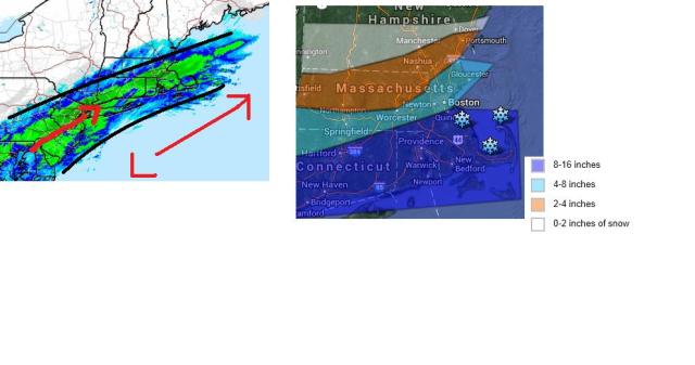
As you can see on current rada . the greens are mainly south of the merrimack valley and that will continue to be the case through 9pm . As areas in between the red lines continue to see near blizzard condtions will struggle to see any real accumulating snowfall. till about 9 pm . This is when some of this heavy snow could lift a bit furthern north. im only expecting 4-8 inches mainly for areas inside of 495. areas outside will be in the the 2-4 range and northern sections will see 0-2 inches. One thing that will not be lacking is the cold. wind chills as low as 15 below can be expected. Even though there will not be much snowfall stil expect areas of drifting and blowing snow. What little snow we do get will not be going any where that fast. as temps will not go above freezing till the weekend.
Forecast.
Tonight periods of snow, snow showers north and west. snow accumulations 4-8 south. 0-4 north. lows around 5 to 0
wednesday. mostly cloudy snow ending. windy and cold, highs in the middle 10s
wednesday night. partly cloudy and cold, lows as low as 10 below
thursday through friday night. partly to mostly sunny highs in the low to mid 10s. lows around zero.
saturday. partly cloudy highs in the upper 20s to low 30s chance of snow showers
saturday night. clearing, lows in the upper 10s to low 20s
sunday. partly cloudy highs in the lower 20s
sunday night. partly cloudy lows in the lower 10s
monday and monday night. partly cloudy. highs in the mid to upper 10s. lows in the single digits.
tuesday. partly cloudy highs in the upper 10s to low 20s
with the snowfall map expect the lower end snowfall accumulations of that area if you are in the orange and light blue shaded regions. This has been difficult to forecast. Artic front moved a tad to far south for this storm to do anything around the merrimack valley. there are a few chances of snow but most of them seem to go well south and east of the region just giving us some clouds.
