
.A typical early spring pattern has taken shape as the cold does not want to leave but the warmth want in. The battle usually involved long periods of damp and cool weather with breaks in between. This will be a perfect example of what I expect to continue right into the middle part of april to early may. This pattern will weaken as we progress through the spring months.
Periods of rain will continue through monday. Temperatures will range from the mid to upper 30s north and upper 30s to low 40s south. Freezing rain will likly mix in the equation both nights for some.
Tuesday and wednesday look like good spring days before our next extended period of showers and periodic rains affect the region again thursday into next weekend.
Forecast.
tonight. Heavy rain with a chance of freezing rain and sleet late. . heavy rain,sleet and freezing rain northwest. lows in the mid to upper 30s.
Sunday. Periods of heavy rain. highs in the upper 30s to low 40s
sunday night. periods of heavy rain and freezing rain. chance of sleet. lows in the low 30s
monday. periods of rain. highs in the upper 30s. chance of freezing rain and sleet early
monday night. chance of rain, snow and sleet showers., lows in the low 30s
tuesday through wednesday night. partly sunny highs in the upper 40s to mid 50s, lows in the low 30s
thursday. increasing clouds, chance of showers, highs in the upper 40s
thursday night. cloudy chance of rain south . chance of rain and snow northwest., lows in the low to mid 30s
Friday through saturday. chance of rain, highs in the mid to upper 40s, lows in the mid to upper 30s.
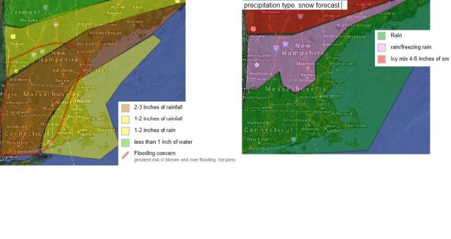
Its going to be a cool and wet spring im afraid… Maps on the top show the amount of water that will fall, the one on the top right snows what the water will be in the form of…. Area in the red circle is where i am most worried about ice jams and flooding… Green on the map to the right shows all rain, The pink areas show where freezing rain could form over tonight and sunday night. The red shows where 4-8 inches of wet snow could fall . most of the lower locations will see about 2-4 inches of snow. Most of the precip p there will be a mix of everything from snow to rain.
Road conditions will be a 3 out of 5. read previous blogs about the scale.
