
As you can see there are 3 storm track, talk about those later. First of all, summer does not end till the middle of September technically. We will have the possibility of 80s and humid weather through September here across the northeast.
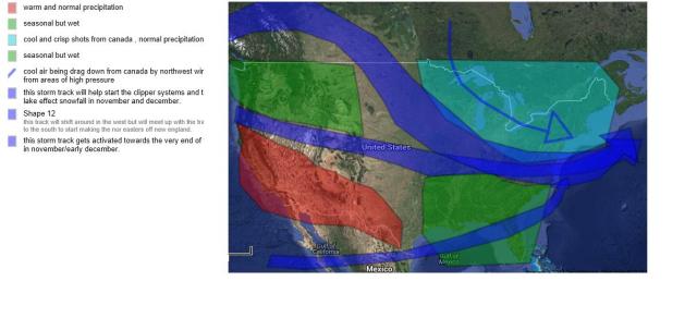
For the northwest seasonal temperatures but above normal precipitation will affect the pacific northwest and parts of the north west Rockies. Durring the fall the storm track will be shifting a bit expecially in the west depending on areas of high pressures over Mexico and over the atlantic ocean. These areas of high pressures will at times push the jets up and at times pull them down. expect near normal precipitation as well as near normal temps but above normal temps in southern California.
In the plains expect near normal temperatures and precipitation, except cooler conditions effecting the northern plains starting in October.
IN the southeast. a series of active storm track will lead to a wet fall but seasonal temperatures. most of the storm track will be to the north through the mid Atlantic but as the fall progresses storms will start grabbing gulf of Mexico moisture. the placement of these storms will be crucial for the northeast forecast.
For the northeast. so much and so complicated as usual, this year i believe a large area of high pressure will take control over eastern Canada/Greenland block. this will allow cool air to be filtered in every now and again and will also lead to some early season clipper systems possibly. storm tracks seem to be favorable for some good size early nor Easter’s. Could see some early snowfall up in northern most new England and higher elevations of NY state. The great lakes could start out early as well. The placement of all these storm paths, are crucial and i will keep an eye out for them for the winter forecast that will come after thanksgiving. Whenever systems merge of the northeast coasts you all know what that means.
the Northern storm track will be consistent, the middle storm track will get active towards the middle to end of fall. the lower will get active towards the end of fall.
Hurricane season Has been extremly quiet. The lowest amount of storms I have seen, a Mixture of weather features have aided the lack of formation of tropical storms and hurricanes in the atlantic basin, including a very strong bermuda high pressure.
