
A moderation in temperatures is ahead for the upcoming weekend. Temperatures will climb into the mid 30s for most of the weekend with some areas seeing low 40s mainly south and east.
The dry conditions will last through the weekend into the beginning of next week. There is a possible storm system to affect the region middle of next week. Will keep you updated. Temperatures for next week will greatly depend on this storm track. It could get really warm ahead of this storm with temperatures soaring into the mid 40s on tuesday Just to drop back down to the low 30s wednesday for the storm.
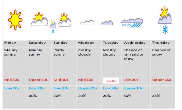
Forecast.
Tonight. clear, lows in the single digits
friday. mostly sunny highs in the 30s
friday night. becoming partly to mostly cloudy. lows in the low 20s
saturday. sunny highs in the mid to upper 30s. but upper 30s to low 40s extreme southern sections
saturday night. chance of snow showers and flurries. lows in the low to mid 20s
sunday through monday partly sunny highs in the mid to upper 30s, lows in the low to mid 20s
monday night. cloudy lows in the upper 20s
tuesday partly to mostly cloudy slight chance of light rain showers. highs in the low 40s
tuesday night. mostly cloudy lows in the upper 10s to low 20s
wednesday.and wednesday night mostly cloudy chance of snow and/or rain. highs in the low 30s lows in the mid 10s
thursday. chance of snow showers partly cloudy. highs in the low 30s
