.snowfall,
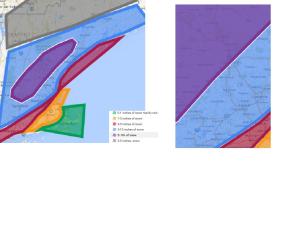
green= mainly rain orange= 1-3 inches (rain to period of snow)
red=3-5 rain to snow
blue 5-10 inches of snow . rain to snow
purple 5-10+ ( highest elevations)

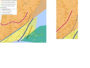
road conditions on a 1-5 scale.
1. minor delays (wet roads) (light green)
2 light delays (wet delays, slush) (dark green)
3 moderate delays secondary roads snow covered)(yellow)
4 heavy delays, snow covered roads (orange)
5 severe delays snow covered high ways. Do not travel (red)
Generalized week forecast.
An area of low pressure will move on out of our area with a partly to mostly sunny tuesday with highs in th 50s. Tuesday night there will be increasing clouds. Wednesday morning looks dry for the merrimack valley,
A mix of rain and snow will move through the region with it changing to snow from northwest/west to southeast/east. Most of the merrimack valley will be snow mid afternoon. Accumulating snow will hold off until the sun sets. Snow will continue through the overnight hours, Heavy at times.
For thanksgiving there will be clouds, and a gusty northerly wind, with highs in the low to mid 30s, as the area of low pressure quickly moves on out of the region. There could be some lingering snow early in the morning.
Highs will be stuck in the 30s through saturday. An area of energy could give the area a chance of snow showers/light snow. We have to watch if the ridge gets far enough north to make temperatures rise a bit….
storm maps. I have the road condition/travel map. and the first numerical snowmap. Models are still pondering on how much, and where the most will happen. Some models are having issues with not remembering that the previous days have been relativily warm. which will limit snow accumulation and help keep roads from getting snow covered until about sunset. for most. Expect moderate delays to start in the the red shaded areas of the map( heavy delays) about an hour after it starts snowing.
(top photo) the snow map. I have two. the map on the left is the new england map and the map on the right is zoomed in onto the merrimack valley.
Merrimack valley Most of the merrimack valley is in the 5-10 inch snow range. northern areas as shown on the map could see some localized higher amounts. as well as the extreme southeast sectionsin the 3-5 inch range.
green= mainly rain with up to 1 inch of snow tail end
orange. rain to a period of snow. 1-3 inches some sleet may mix in
red rain to snow. 3-5 inches of snow.
blue= mix of rain and snow to snow 5-10 inches of snow
purple.= mainly snow. 5-10 inches of snow with locally higher amounts.
With the second map. Shows the road condtions, time of rain to snow, (approximation) and delays.
orange. heavy delays. mainly between the hours of 3pm to 7 am with moderate delays 7am-10am
yellow. moderate dealys possible 5pm-7am with light delays 7am to 10am
green. light delays possible from 3pm wednesday to 9am
rain to snow change over
REd line shows snow/rain line reaching around 1pm
first blue line .is around 2 to 3 pm
2 blue line is 4-6pm
brown line is anytime after 9pm
This is the first detailed forecast Will update again tomorrow.
