
storm.. precipitation will start to over spread the region around 2pm snow will not take long to become heavy as a storm bombs out southeast of cape cod.
The national weather sevice has issued a blizzard warning for coastal communities from this afternoon through tonight.
winter storm warnings have been issued for eastern massachusetts
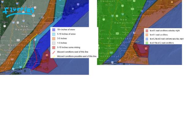
This storm will have a sharp cut off. What i mean by this is that only a few miles could make a difference of 8 or 10 inches to 4 inches. or none.
With this system the talk will be the wind. sustained winds of 45mph+ are possible over the south coast, cape and islands with gusts up to 65mph
winds on the rest of the coast will rainge from 30-40mph with gusts up to 50.
areas east of i95 will have winds of 25-30mph with gusts of 35+
areas inside of 495 will see winds of 10-25mph with gusts of 30+
Exact track is still a tad uncertain at the moment
precipitation. At first it was thought this storm would be far enough out that there would be no mixing besides for possibly nantucket but now this storm looks to be stronger and a tad closer so mixing is possible on the outer cape and islands.
For now jack part areas would be eastern plymouth county
in interior northeast massachusetts your amounts could vary greatly from 4 to as much as 10 inches depending on exact track and how far the heavy snow makes it. much lesser amounts the further northwest you go. Vermont will likly only see flurries or light snow showers.
Another storm could affect us monday night into tuesday.
alot of unknows past wednesday.
