
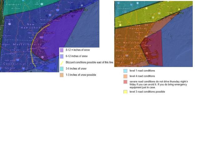
If you do not want to hear the details go to the ( *) points underneath.)Today will feature increasing clouds through the afternoon. light snow could develope as early as midnight tonight. snow will fall lightly through tonight into the morning thursday. the snow will intinsify in intensity late thursday morning and early thursday afternoon. many schools will have to decide to cancel school or have an early release. the snow will start to fall heivy thursday afternoon through friday morning. snow fall rates could go 1 to 3 inches per hour in the heiver bands expecially in eastern massachusetts. Blizzard conditions are possible thursday night through friday. east of the yellow line on the map. In order for it to be called a blizzard you need at least 3 hours of all of the following. snowfalling OR BLOWING SNOW . reduce visibilites to near white out conditions. with winds of 35 mph or frequent gusts .
This is mostly likly to happen in northeast massachusetts. closer to the coast. this will be a “dry snow” very low water content. This will lead to alot of blowing snow even after the snow stops falling. Actual temperatures will not go above 20 degrees besides for possibly the south coast and cape. possibly. With the winds this will mean we will have wind chills near or below zero for most of the duration of this storm. Wind chills on thursday night will be as low as -25 . Please try to avoid to be outside for long periods of time thursday night and friday morning.
For schools. i say about a 40% chance of cancelations thursday 60% chance of early releases. friday. 90% of school closings. I will update maps through out the afternoon and evening. Jackpot areas for snowfall will be in northeast massachusetts and areas just outise of the 10mile mark from the coastlines.
* light snow starts after midnight tonight
* heiver snows start after 10am thursday through friday morning
* snow starts to taper off friday afternoon. light snow continues till dark in some locations
* Blizzard conditions possible from 5pm thursday through friday
* temperatures low to middle 10s , lower 20s coastline. middle 20s cape and islands
* wind chills. as low as negative 25 degrees thursday night.wind chills near or below zero thursday and friday
* a general 6-12 inches of snow expected with much higher amounts possible in the purple shaded areas.
Be safe and stay warm. if power goes out find a warm place to stay.
