
As mentioned in previous blog an artic blast will help lock very cold air in place for this week. Setting the stage for a now probable major northeast snow storm. yes i said snow storm. not winter storm. Been a while since i am able to say that.. usually always talking about a snow or rain line. That is not the problem with this system. Plenty of cold air will be in place for this system. the problem is does this system go well to the south still giving the region a good snowstorm do to ocean effect snows. How long will this storm be. How much will there be. how much wind, how bad is it for the coast.
For the coast this storm could not have came at a worse time. The tides will be very high thursday through friday . This storm will be elongated as well allowing seas to build on top of already high seas so we could be talking some coastal concerns will get more in detail with that in future updates.
the wind could be very strong creating blizzard like conditions along the coast at times. If the Euro weather model scenerio happens.
To the snow discussion. there are 3 possible out comes. yes 3 days out and there is huge disagreements between weather models. Welcome to new england folks.
scenerio 1. This storm goes well to the south and east. though with the temperature contrast between the air mass and 40 degree ocean water could mean a major ocean effect snow event for eastern parts.
scenerio 2
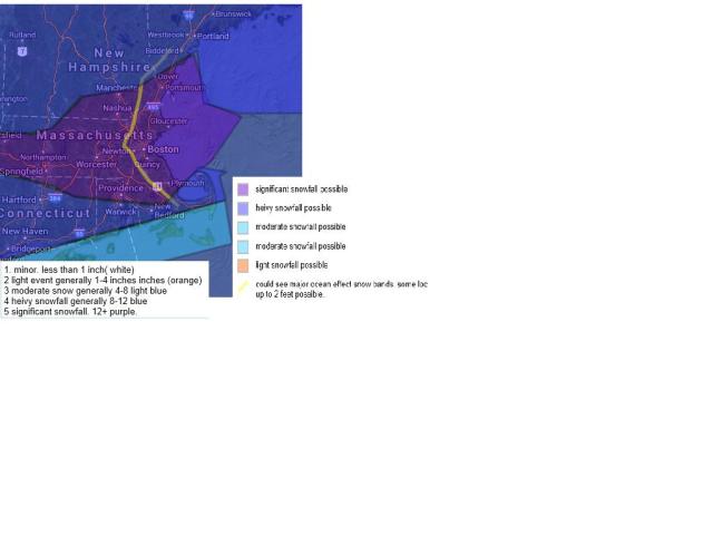
Elongated snow storm from wednesday night through friday into friday evening. this will mainly be light snow to moderate snow with heivier bands expecially closer to the coast. this scenerio dumps a hievy snowfall for the area shaded in purple and moderate snowfall in the blue shaded area.
scenerio 3 is a classic nor easter that will develope off the virginia coast and effect the region from thursday mid afternoon through friday morning. dumping more than 15 inches of snow across the region in the purple shad
I am currently thinking a blend between scenerio 2 indicated by the Gfs weather model and secerio 3 indicated by the Euro weather model. I am thinking light snow developes thursday morning and the light snow continues through the early afternoon. The snow will start to pick up in intinsity the the early afternoon and intinsify . the hievy snow will end around noon time friday though light snow will continue through the afternoon. expecially along the coast where ocean inhance snow bands will likly help snowfall. the area shaded east of the yellow line is where i think ocean inhance snow could form. Letting some areas receive alot more than others.
I will keep you updated, this storm has huge bust potential as many things can go wrong. I am still worried that the very cold air could chew away from the northern part of the storm. or push it well to the south and east. thats why scenerio 1 is up.

based on what I just read on the weather page it looks like your predictions are spot on!!