
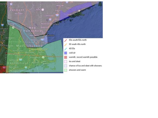
An area of low pressure will travel to the west and north of the region bringing along with it a warm front which will bring showers acrosss southern new england, the storm will bring heivy rain to northern new england . The problem is that there is a cold air mass to the north that will fight the warm air. This setting up a major ice storm for northern new england. temperatures up there will be in the lower 30s and even upper 20s though some of the higher elevations could actually see plain rain who go into the warm column. They could see more than a half an inch of ice in some parts of northern new england.
South of the pike the warm front will win out and warm temperatures to near record warmth parts of CT could see temperatures soar into the middle to upper 60s. areas south of the red line show where the 60s are possibe with north of the red line being in the 50s and 40s. Now this is where it starts to get tricky many models are showing that the warmth go all the way to the massachusetts boarder but more models hint at the cold air being stronger and move into the northeastern sections of massachusetts. (forcasted area) We could see highs in the lower 50s early before sun rise but temperatures fall through the morning and will be in the upper 30s by the afternoon. we could see some of the precipitation fall as freezing rain or sleet across northeastern massachusetts and the higher elevations of central mass.
showers will continue through monday. before clearing out monday night . highs on christmas eve will bei n the upper 20s, with christmas eve possibly even colder with highs in the lower 20s.
forcast
sunday. mostly cloudy, highs in the the upper 40s to lower 50s, temps dropping to the middle 30s , showers likly with a chance of freezing rain and sleet. winds from the south turning north, northwest.
sunday night. chance of rain,sleet,freezing rain and snow showers. lows in the low 30s. no snow or sleet accumulation.
monday. mostly cloudy showers likly. highs in the low to middle 40s
monday night. cloudy chance of rain and snow showers., lows in the middle 20s
tuesday. sunny highs in the upper 20s
tuesday night. much colder. lows in the single digits possible
christmas day. cold highs inthe low 20s but upper 10s higher elevations.
christmas night. not as cold with lows in the middle 20s. cloudy with a chance of snow showers.
friday mostly sunny. not as cool highs inthe lower 30s
friday night. clear lows in the low 20s
saturday. cool highs in the upper 20s
If you are traveling into northern new england please be safe. i do not recomend it. On my road condition scale of 1-5 i am putting a 2 for southern new hampshire/vermont eastern down east maine. with a 3 for everyone else in northern new england. level 1 for all of massachusetts and the rest of southern new england.
