
Good dumping. Snow will start to fall for everyone in the region. light snow will start to spread across the region in the mid afternoon hours and will pick up in intinsity after nightfall.
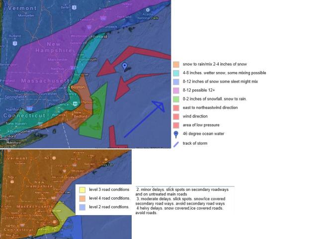
snowfall across areas north of the pike and west of i95 are almost in stone. areas south of the pike and areas east of i95 is the trouble and will continue to see shifts in forcast amounts through tomorrow morning and early afternoon. will be a now casting problem of how far inland does the rain and mix move in. If this was january and the ocean temperatures were colder this could of been an entire snow event for almost everyone but maybe the outer cape but it is not january, the ocean temperatures are in the low to middle 40s which will help limit snow accumulations across areas that get effected by south, and east facing winds. The streangth of these winds will greatly influence how far inland the rain and mix happens. All precipitation will end from southwest to northeast sunday. Most will see it end by 1 or 2pm. stay tuned to later adjustments. As it will be needing to be adjusted. expecially south and east of boston.

Hi Matt…It’s Keith-Hngham. I hope you were joking about your comments about UMass and the area. I posted my public reply on Woods Hill but just wanted to set the record straight privately. The school is great. No longer a Party School and my son is a computer science major with a gpa of 3.8. So I take any negative comments about the school and the area seriously.
it is still a party school my freinds talk about it. sorry if its insulting but it has the most problems of all the umass schools.