
As today comes to a close, we will see temperatures plummet into the lower 10s
friday will feature mostly to partly cloudy skies. As an other front moves through from the northwest a few flurries could happen in the afternoon. Highs will be in the middle 20s
friday night will become mostly cloudy with lows in the upper single digits which will help keep most area as snow saturday night through sunday morning.
Timing of system. scattered light snow showers could effect the region in the morning though a steadier light snow will develope through the afternoon. the moderate to heivier snow will fall closer to sunset and last through sunday morning. Highs saturday will be in the lower 20s
highs sunday will be in the upper 20s with snow ending in the afternoon.
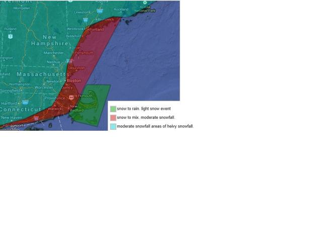
Snowfall is still a tad uncertain though I am generally thinking anyone outside of i95/128 will see a moderate snowfall with some areas seeing heivy snowfall possibly due to fluff factor(high snow ratios) An other factor that will help snowfall accumulations is that most of it will fall durring the time that the sun is not out. this will greatly effect road ways.
I said i was going to do a new system with snowfall though last year i developed a road condition scale. a 1-5 scale.
Everyone will be fine till around 4-6pm. level 1 road conditions.
after 6.pm expect road ways expecially secondary roads to quickly become snow covered. I am putting a level 4 road condtions for saturday night. for all but areas south and east of boston where level 2 and 3 level road conditions will persist depending on precipitation type.
this storm system moves on out and the cold air sticks around till the middle of next week with a slight moderation in temperatures by wednesday or thursdya highs will be in the low to middle 30s. Tuesday we could see some snow showers which would be a level 1 event.(minor snowfall)
1.some minor delays. some slick spots mainly on secondary road ways
2. minor delays. slick spots on secondary roadways and on untreated main roads
3. moderate delays. slick spots. snow/ice covered secondary road ways. avoid secondary road ways
4 heivy delays. snow covered,ice covered roads. try to avoid driving
5 severe delays and road closures crews not able to keep up with snow and or ice. do not travel.